Weathering the Storms
Another Atlantic hurricane season is promising to be an active one, but Central Floridians can find some peace of mind with diligent, proactive awareness and preparation.
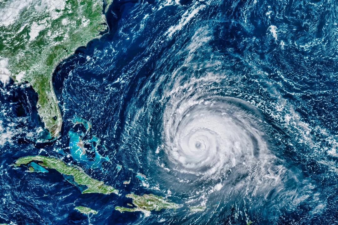
There’s not a storm brewing in the Atlantic basin yet, but the conditions are right for Floridians to face another active hurricane season.
It’s still too early to know how many of those anticipated storms will impact The Sunshine State, but there is still plenty of time to prepare yourself, your loved ones, your property and even your neighbors for facing a worst-case scenario while both placid conditions and cooler heads prevail.
“We like to empower and educate our audience so that they can take time and evaluate how they were impacted last year, the potential weak points on their property, the potential things that your family will need if the power goes out,” says Megan Borowski, senior meteorologist for the Florida Public Radio Emergency Network. “We want to get people thinking about if they have to be in a shelter-in-place or an evacuation scenario, what will they need to be able to survive and be as comfortable as they can be. The more preparation and thought you put into things ahead of time, the easier it’s going to be to act and not be as disrupted when a storm impacts your area.”
Since the hurricane season officially spans June 1 through Nov. 30, most 2025 forecasts hadn’t been released as of Orlando Family Magazine’s press time; in April, however, Colorado State University posted its preseason prediction of 17 named storms, nine hurricanes, and four major hurricanes (category 3 and higher)—slightly more than the average of 14 named storms, seven hurricanes and three major hurricanes.
Of course, that doesn’t mean every hurricane will take aim at Florida, though longtime broadcast meteorologist Brian Shields points out that forecasts only tell a fraction of the story. He notes how “some of the worst damage we’ve seen has come from tropical storms and category 1 hurricanes, as well as rapidly intensifying storms.
“Every year, there could be a million hurricanes but if they stay in the open water of the Atlantic, that turns outs to be what people consider not a very busy season,” he says. “We just don’t know where a storm will go until either one develops or we get a good handle on the pattern. … We’ve seen storms that have gone from nothing to something very quickly: That’s when we talk about the storms rapidly intensifying, and that’s always a concern because it’s my job to keep people prepared and safe. If a storm goes from a tropical storm to a category 4 hurricane within a matter of 36 hours, that’s a big problem.”
Numerous factors influence the conditions that can either feed into or mitigate the season’s storms. A strong wind shear—the change in wind speed, wind direction or both, over a distance—is one element that can combat heavy storms by disrupting a hurricane’s structure and weakening its ability to draw in warm, wet air, while the dry, dusty air from Africa’s Sahara Desert can have a similarly storm-diminishing effect. The ocean waters off the Floridian coast are also cooler than they were this time last year, which is decidedly good news even if they are still warmer than the seasonal average.
Additionally, the 2025 seasons marks a neutral period in the oscillation between El Niño and La Niña climate patterns: The latter typically means less wind shear and more named storms, while the former tends to bring more wind shear, fewer named storms and more spinoff tornadoes. A neutral phase does historically align with more named storms.
But just because all those ingredients have amounted to a close call and a sigh of relief for many before, it doesn’t mean luck will prevail again—and allowing complacency to rule your decisions can be deadly.
“Every storm is different, every storm’s track is different, the extent of the impacts are different,” Borowski says. “You’ve got to take each storm as its own unique entity and look at what forecasters and the National Hurricane Center are issuing as the major hazards from the particular storm that’s breathing down your neck. Don’t go based off past experiences, because the one time that you do that is going to be the time that it could really impact your life.”
While being in the direct path of a hurricane is certainly a terrifying reality with significant risk to people and property, the danger doesn’t pass once the storm does. Both Borowski and Shields explain that being on the periphery of that terrifying ferocity can spell disaster by way of storm surges, flooding, tornadoes and compromised infrastructure, regardless if you live in a coastal or more inland locale.
“We do a very good job of evacuating the coast if a major hurricane is headed there,” begins Shields. “But inland, we don’t have as many evacuations—and we need to watch out for inland flooding because that water is not pleasant. It could spread sicknesses, there could be powerlines in it, there could be creatures in that water. And we could lose quality drinking water for a solid period of time. There’s a big ripple of impacts as you go inland.”
Unpredictability is always an uncomfortable reality to sit with, especially when it comes to something as significant as protecting one’s family, home and community. It’s impossible to know how you and your loved ones will react when faced with an imminent hurricane scenario, but having a hurricane go-bag or survival kit, options for shelter and an evacuation plan can help counteract some of that anxiety and uncertainty.
“You do not need to evacuate hundreds of miles—sometimes you just need to go 10, 20 miles further inland,” Borowski explains. “The biggest thing for evacuations is being able to get out of the zone for storm-surge flooding and, if [the hurricane] is making landfall, to get away from where the strongest winds are occurring, right within the eye wall. I know it’s easier said than done, but if you’re in an evacuation zone and you’re planning on where you’re going to evacuate to, you can go online and see where all the evacuation sites are and whether they’re pet-friendly, and you’ll see that it doesn’t have to be a day’s journey.”
For those dealing with a storm’s ruinous aftermath, you’re not navigating that overwhelming task alone.
“Florida’s municipalities work together through a strong network of collaboration and communication, particularly during and after weather-related crises,” notes Jeff Branch, director of field advocacy and emergency management for the Florida League of Cities (FLC). “I serve as a liaison between our cities and state and federal emergency management partners to ensure local needs are prioritized and addressed. Following a storm, cities immediately assess damage, restore critical services and begin recovery operations. Through mutual aid agreements and regional coordination, municipalities can quickly deploy resources and personnel to assist one another.”
Times of crisis do have a way of strengthening community and connecting neighbors, especially if a residential area is temporarily cut off from emergency services and those supplying critical aid. Evacuation is not always an option for individuals with limited mobility, high-support medical needs, or loved ones who can’t be relocated easily or safely, and a friendly neighbor might be their only lifeline in the face of catastrophic weather events.
But there are mechanisms and procedures in place that help affected municipalities facilitate quick-moving recovery and assistance processes so residents can be assured help is on the way.
“The [FLC] also facilitates real-time information sharing among city officials, helping local leaders connect, troubleshoot challenges, and request additional support when needed,” Branch affirms. “By maintaining strong pre-disaster relationships, Florida’s cities are better equipped to respond as a united front—ensuring that affected areas receive timely help, support and resources to recover as quickly and efficiently as possible.”
There’s no crystal ball to say for sure how this year’s hurricane season will impact Florida, but equipping and empowering yourself with facts can go a long way in meeting above-average activity with a solid plan and a clear head.
“We’re always concerned about complacency but I do think people are a little more aware of the risks, based on the last couple of years of bad hurricanes, even inland,” Shields says. “My best advice is to stay aware because knowledge is power. If a hurricane is coming toward us, even if it is not super strong or doesn’t seem like it will be, it can still dump a lot of rain on us or rapidly intensify. It’s always best to prepare for something a little stronger than predicted.”
|
WINDOWS & DOORS FL Shutters Florida Window & Door Solutions Hurricane Protection Solutions & Blinds Renewal by Andersen |
GENERATOR Strada Electric
OUTDOOR LIVING MD Construction
|